|
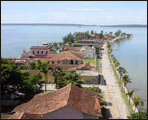
The South Pearl is located 250 kilometres southeast of the capital of Cuba . To be more precise, it is situated on the northwest shore of the bay with the same name where there is also one of the most important ports in the Caribbean, not  only due to the shipping of goods but also because of the recent starting up of an oil refinery. only due to the shipping of goods but also because of the recent starting up of an oil refinery.
It is the administrative centre of the province with the same name at latitude 21 degrees and 21 seconds and 23 degrees and 35 seconds north and at longitude 80 degrees and 20 seconds and 81 degrees and 10 seconds west.
It extends over 3.77% of the Cuban territory, that is, 4 177.2 sq km. It borders on the Caribbean Sea to the south, Villa Clara Province to the north, Sancti Spíritus to the east and Matanzas , the province where the beautiful Varadero beach is situated, to the west.
 |
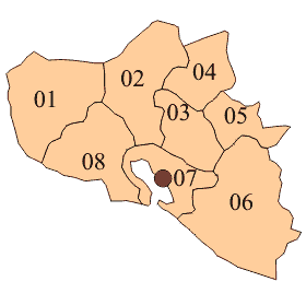
| Municipality |
01 Aguada de Pasajeros
02 Rodas
03 Palmira
04 Lajas
05 Cruces
06 Cumanayagua
07 Cienfuegos
08 Abreus
 |
|
| Statistics |
1999 |
| Surface area |
4 178 km2 |
| Resident population |
395 135 inh |
| Average population |
393 744 |
| Female population |
49,5 |
| Population in working age |
234 020 |
| Urbanization index |
80,7 % |
| Population density |
94,6 inh/ km2 |
| Life expectancy at birth (1994-1995) |
75,85 |
| Birthrate |
13,4 |
| General mortality rates (per 1000 live) |
7,4 |
| Infant mortality rate(per 1000 live births) |
5,9 |
| Fecundity global rate (children per woman) |
1,61 |
| Reproduction gross rate (daughters per woman) |
0,78 |
| Inhabitants per physician |
183 |
| Inhabitants per dentist |
1 175 |
| Initial matricula (Course 1999/2000) |
78 450 |
| Primary education |
34 050 |
| Intermediate education |
30 450 |
| Higher education |
3 087 |
| Graduates (Course 1998/1999) |
15 186 |
| Primary education |
5 716 |
| Intermediate education |
7 272 |
| Higher education |
436 |
|